You can Download Samacheer Kalvi 6th Social Science Book Solutions Guide Pdf, Tamilnadu State Board help you to revise the complete Syllabus and score more marks in your examinations.
Tamilnadu Samacheer Kalvi 6th Social Science Geography Solutions Term 3 Chapter 1 Asia And Europe
Samacheer Kalvi 6th Social Science Asia And Europe Textual Evaluation
I. Choose the best answer:
Which is not the western margin of Asia?
(a) Black Sea
(b) Mediterranean Sea
(c) Red Sea
(d) Arabian Sea
Answer:
(d) Arabian Sea
Question 2.
The Intermontane …………… plateau is found between Elbruz and Zagros.
(a) Tibet
(b) Iran
(c) Deccan
(d) The Yunnan
Answer:
(b) Iran
Question 3.
Equatorial climate :
- Uniform throughout the year.
- The average / mean rainfall is 200 mm.
- The average temperature is 10°C. Of the statements given above,
(a) i alone is correct
(b) ii and iii are correct
(c) i and iii are correct
(d) i and ii are correct
Answer:
(a) i alone is correct
Question 4.
Match list I correctly with list II and select your answer from the codes given below.
Answer:
(a) 2, 3 ,4, 1
Question 5.
India is the leading producer of ……………
(a) Zinc
(b) Mica
(c) Manganese
(d) Coal
Answer:
(b) Mica
![]()
Question 6.
The natural boundary between Spain and France is _________
(a) The Alps
(b) The Pyrenees
(c) The Carpathian
(d) The Caucasus
Answer:
(b) The Pyrenees
Question 7.
The western and north – western Europe enjoys mild and humid climate. Choose the correct option:
(a) These regions are found near the equator
(b) It is influenced by the North Atlantic Drift
(c) It is surrounded by mountains
(d) All of the above
Answer:
(b) It is influenced by the North Atlantic Drift
Question 8.
Which of the following statements is incorrect?
(a) Europe produces electricity from hydel power
(b) All the rivers of Europe originate in the Alps
(c) Most of the rivers in Europe are used for inland navigation
(d) The rivers of Europe are perennial in nature
Answer:
(d) The rivers of Europe are perennial in nature
Question 9.
Choose the incorrect pair.
(a) The Meseta – Spain
(b) The Jura – France
(c) The Pennines – Italy
(d) The Black Forest – Germany
Answer:
(c) The Pennines – Italy
Question 10.
Which country in Europe has a very low density of population?
(a) Iceland
(b) The Netherlands
(c) Poland
(d) Switzerland
Answer:
(a) Iceland
II. Fill in the blanks :
- The Taurus and the Pontine ranges radiate from the knot.
- The wettest place in the world is
- Iran is the largest producer of in the world.
- Europe connected with south and southeast Asia by
- The national dance of Philippines is.
- The second highest peak in Europe is.
- The type of climate that prevails in the central and eastern parts of Europe is.
- The important fishing ground in North Sea is.
- The density of population in Europe is.
- The river passes through nine countries of Europe.
Answer:
- Armenian
- Mawsynram
- Dates
- Suez
- Tiniklingi
- The Mont Blanc (4,807m)
- Continental type
- Dogger Bank
- 34 persons / km2
- Danube
III. Match the following :
- Mesopotamian Plain – (a) Highest Rainfall
- Mawsynram – (b) Norway
- Rice Bowl of southeast asia – (c) Spain
- Fjord Coast – (d) Euphrates & Tigris
- Bull Fighting – (e) Thailand
Answer:
- (d)
- (a)
- (e)
- (b)
- (c)
IV. Let us Learn:
Question 1.
Assertion (A): Italy has dry summers and rainy winters
Reason (R): It is located in the Mediterranean region
(a) Both A and R are individually true and R is the correct explanation for A
(b) Both A and R are individually true but R is not the correct explanation for A
(c) A is true, but R is false
(d) A is false, but R is true
Answer:
(a) Both A and R are individually true and R is the correct explanation for A
![]()
Question 2.
Places marked as 1, 2, 3 and 4 in the given map are noted for the following plains.
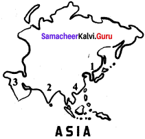
A. Indo – Gangetic plain
B. Manchurian plain
C. Mesopotamian
D. Great plains of China
Match the plains with the notation on the map and select the correct answer using the codes given below.
Codes:

Answer:
(b) 2 1 3 4
Question 3.
In the given outline map of Asia, the shaded areas indicate the cultivation of
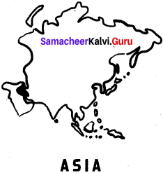
(a) Sugarcane
(b) Dates
(c) Rubber
(d) Jute
Answer:
(b) Dates
V. Answer in Brief:
Question 1.
Name the important intermontane plateaus found in Asia.
Answer:
The plateau of Anatolia, The plateau of Iran and the plateau of Tibet are the important intermontane plateaus found in Asia.
Question 2.
Write a short note on monsoon climate.
Answer:
- The south, south east and eastern parts of Asia are strongly influenced by mansoon winds.
- Summer is hot and humid. Winter is cool and dry.
- The summer mansoon winds bring heavy rainfall to India, Bangaladesh, Indo – China, Philippines and southern China.
Question 3.
How does physiography play a vital role in determining the population of Asia?
Answer:
- In Asia, the population is unevenly distributed because of various physical features.
- China and India alone covers three fifth of Asia’s population.
- River plains and industrial regions have high density of population, whereas low density is found in the interior parts of Asia.
![]()
Question 4.
Name the ports found is Asia.
Answer:
- Tokyo
- Shanghai
- Singapore
- Hongkong
- Chennai
- Mumbai
- Karachi
- Dubai
Question 5.
Asia is called the ‘Land of Contrasts’- Justify.
Answer:
- Asia is the biggest continent has different types of land features such as mountain,plateau, plain, valley, bay, island etc.
- It has different climatic conditions from the equator to polar region.
- Apart from this many races, languages, religions and cultures are followed by people who live in Asia. Therefore, Asia is called ‘the land of contrasts’.
Question 6.
Name the important mountains found in the Alpine system.
Answer:
- The Sierra Nevada
- The Pyrenees
- The Alps
- The Apennines
- The Dinaric Alps
- The Caucasus
- The Carpathian.
Question 7.
What are the important rivers of Europe?
Answer:
The important rivers of Europe are Volga, Danube, Dnieper, Rhine, Rhone, Po and Thames.
Question 8.
Name a few countries which enjoy the Mediterranean type of climate.
Answer:
- France
- Spain
- Italy
- Sicily
![]()
Question 9.
Give a short note on the population of Europe.
Answer:
- Europe is the third-most populous continent, after Asia and Africa. The population density in Europe is.34 persons / km2.
- High population density is often associated with the coalfields of Europe.
- Other populous areas are sustained by mining, manufacturing, commerce, offering large market, labour forces and productive agriculture.
- Monaco, Malta, San Marino, and the Netherlands are the most densely populated countries; Iceland and Norway have very low density of population.
Question 10.
Name the important festivals celebrated in Europe.
Answer:
- Christmas
- Easter
- Good Friday
- The saint
- Day
- Redentone
- Tomatina
- Cornival
VI. Distinguish.
Question 1.
Intermontane plateaus and Southern plateaus
Answer:
Intermontane plateaus:
- Intermontane plateaus are found in the mountain ranges.
- Eg, The plateau of Anatolia, The plateau of Iran and the plateau of Tibet
Southern plateaus:
- The southern plateaus are relatively lower than the northern plateaus.
- Eg. Arabian Plateau, Deccan Plateau, Shan Plateau and the Yunnan Plateau.
![]()
Question 2.
Cold desert and hot desert
Answer:
Cold desert:
- Gobi
- Taklamakan
Hot desert:
- The Arabian (Saudi Arabia)
- The Thar (India and Pakistan)
The largest desert in Asia is the Arabian Desert.
Question 3.
Thunder and Taiga
Thunder:
- The Arctic and northern Scandinavian highland have Tundra type of vegetation.
- The winters are very long and severe summers are very short and warm.
- It is the land with few animals like polar bear, reindeer and walrus
- No trees. Lowest form of vegetation like Mosses and Lichen only available.
Taiga:
- They are found in the south of the Tundra region in Norway, Sweden, Finland, Germany, Poland and Austria.
- The winters are long and cold. Summers are short and warm.
- It is the land of fur bearing animals. Eg. Mink, silver fox, squirrel etc.
- Pine, fir, spruce and larch are the important tree varieties.
![]()
Question 4.
The North western highlands and the Alpine mountain range.
Answer:
The North Western Highlands:
- This region includes the mountains and platea us of Norway, Sweden, Finland, Scotland and Iceland.
- This region has fjord coast. It was created by glaciations.
- A lot of lakes here serve as reservoirs for producing hydro electricity.
The Alpine mountain range:
- The Alpine mountain system consists of a chain of young fold mountains found in the southern part of Europe.
- The Sierra Nevada, the pyrenees, the Alps, the Apennines, the Dinaric Alps, the Caucasus and the
- Carpathian are the important mountain rangers.
- The Pyrenees is a natural boundary between Spain and France.
VII. Give Reasons:
Question 1.
Asia is the leading producer of rice.
Answer:
- In Asia, India has the largest area of arable lands.
- Agriculture is intensively practised in the riverine plains of Asia
- China and India are the leading producers of rice in the world.
Question 2.
Asia is the largest and most populous continent in the world,
Answer:
- Asia is the most populated continent in the world.
- Approximately six tenth of the world population lives in Asia.
- The population is unevenly distributed because of various physical features.
- China and India alone covers three fifth of Asia’s population.
- River plains and industrial regions have high density of population.
Question 3.
Europe is called ‘a giant peninsula’.
Answer:
- Europe is found in the northern hemisphere.
- It covers an area of 10.5 million sq.km.
- It is surrounded by the Arctic Ocean in the North, the Black Sea and Mediterranean Sea in the south, the Atlantic Ocean in the west and the Ural mountains in the east.
- So it loots like a giant peninsula.
Question 4.
Although Western Europe is located in the high latitudes, it Isas a moderate climate.
Answer:
- North Atlantic Drift is a warm ocean current which brings warmth to the western Europe.
- The westerly wind further transports warmth across Europe.
VIII. Answer in Paragraph
Question 1.
Give an account of the drainage system in Asia,
Answer:
- The rivers of Asia originate mostly from the central highlands.
- The Ob, Yenise and Lena are the major rivers that flow towards the north and drain into the Arctic Ocean.
- These rivers remain frozen during winter.
- On the other hand, South Asia has many perennial rivers like Brahmaputra, Indus, Ganga and Irrawaddy.
- These rivers originate from the snow covered high mountains that do not freeze during winter.
- The Euphrates and Tigris flow in West Asia.
- The Amur, Huang He, Yangtze and Mekong rivers flow in the south and south eastern parts of Asia.
- Yangtze is the longest river in Asia.
![]()
Question 2.
Describe the mineral sources found in Asia.
Answer:
- Iron ore : Asia has the largest deposits of iron ore in the world. China, India, Turkey, Philippines, Malaysia, Thailand, Myanmar have iron ore deposit.
- Coal : Coal is a fossil fuel. Asia has the largest deposits of coal in the world. China and India are the largest producers of coal in Asia.
- Petroleum : Petroleum is a mineral oil. South west Asia has the largest petroleum reserves. Saudi Arabia, Kuwait, Iran, Bahrain, Qatar and UAE are important Petroleum producing countries. Other countries are South China, Malaysia, Brunei, Indonesia, India and Russia.
- Bauxite is found in India and Indonesia.
- Mica is found in India
- Tin is found in Myanmar, Thailand, Malaysia and Indonesia.
Question 3.
What are fjords? How do they protect harbours from bad weather conditions?
Answer:
- In Europe, the North Western Highlands region includes the mountains and plateaus of Norway, Sweden, Finland, Scotland and Iceland.
- This region has the most beautiful fjord coast.
- It was created by glaciations in the past.
- This region has a lot of lakes, which serve as reservoirs for producing hydroelectricity.
- A fjord is a narrow and deep sea inlet between steep cliffs. It helps in the following ways.
- It reduces the speed of wind, irrespective of its direction.
- The force of sea waves are also controlled.
- Hence, areas with fjords are best suited for natural harbours.
![]()
Question 4.
Describe the climatic divisions of Europe.
Answer:
- The climate of Europe varies from the subtropical to the polar climate.
- The Mediterranean climate of the south has warm summer and rainy winter.
- The western and north western parts have a mild, generally humid climate, influenced by the North Atlantic Drift.
- In central and eastern Europe, the climate is humid Continental type.
- In the northeast subarctic and tundra climates are found.
- The whole of Europe is subject to the moderating influence of prevailing westerly winds from the Atlantic Ocean.
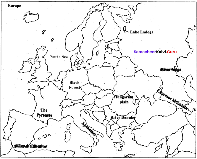
IX. Map Skill:
Mark the following in the outline map of Asia and Europe.
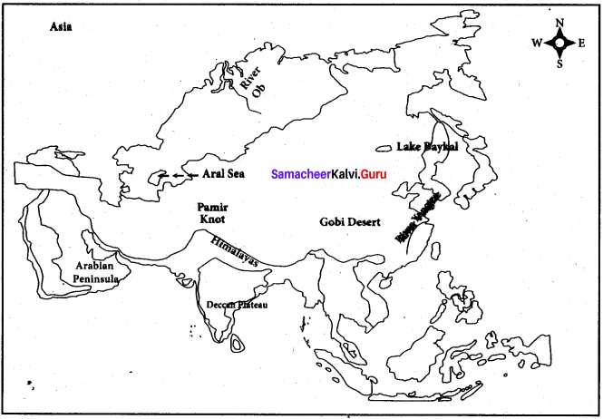
Asia : Ural mountain, Himalayas, Pamir knot, Gobi Desert, Arabian Peninsula, Deccan plateau, River Yangtze River Ob, Aral Sea and Lake Baykal.
Europe : The Pyrenees, Black forest, Apennines, Hungarian Plain, Caucasus Mountain, River Volga, River Danube, Strait of Gibraltar, Lake Ladoga, North Sea
Answer:
HOTS:
Question 1.
The Khyber Pass is located in the Sulaiman range, the Bolan Pass is located in Toba Kakar range. What is the importance of these two passes?
Answer:
(i) Khyber Pass : A mountain pass in the northwest of Pakistan on the border with Afghanistan. It connects the town of Landi Kotal to the valley of Peshawar. An integral part of the Silk Road, it has long substantial cultural, economic, and geopolitical significance for Eurasian trade. It is an important trade route between Central Asia and South Asia and a vital strategic military choke point.
(ii) Bolan Pass : A mountain pass through the Toba Kakar range of Balochistan province in western Pakistan. Strategically located, traders, invaders, and nomadic tribes have also used it as a gateway to and from South Asia. The Bolan Pass is an important pass on the Baluch frontier, connecting Jacobabad and Sibi with Quetta.
![]()
Question 2.
There is no winter in the equatorial region. Why?
Answer:
- At the equator there are no seasons because each day the Sun strikes at about the same angle.
- Every day of the year the equator receives about 12 hours of sunlight. The poles remain cool because they are never tilted in a direct path of sunlight.
Question 3.
Few countries in Asia have high population. Give reasons.
Answer:
- China and India have historically been very large sized nations as opposed to European and other countries. So large nations obviously means large population,
- People used to have large number of children, because few would survive beyond age 5 due to disease and malnutrition. The average longevity in India in 1947 was just 38 years, but now it is over 60.
- Post-independence, health services were expanded and child mortality came down. This also caused an increase in life span. But the rate of child bearing came down much more slowly, which led to a population explosion.
- With improving health care and education, and less fear of a child dying, the rate of growth has been coming down. In the southern states, where education and health services are better, it has actually now reached a stable level.
- The rise of industry and large-scale agriculture meant that families could be much bigger than they had been in the past.
- The social effects of the rural-urban divide led to more complex societies, more cities, and many more people.
Question 4.
Europe is called as the ‘Peninsula of Peninsulas Justify.
Answer:
(i) A peninsula is an extension of land surrounded on three sides by bodies of water. Europe is an extension of the super continent Eurasia and is surrounded by the Mediterranean sea to the south, the Baltic sea and North sea to the north and the Atlantic ocean to the west.
(ii) On the peninsula of Europe, there are five large peninsulas. The Iberian (Spain and Portugal), the italic (Italy), The Peloponnesian (Greece), Scandinavian (Norway and Sweden) and Finland (Denmark).
![]()
Question 5.
Why are European rivers suitable for inland navigation?
Answer:
- The western Europe has a navigable waterways network of about 19,000 kms. Inland waterway transport plays an important role for the transport.
- Europe has 45,000 kms of navigable waterways which is more than what even USA has (40,000 kms). A waterway is navigable only if the water is deep, slow and wide enough for certain types of ship to pass through.
- Europe has two main flat regions, the North European plain and the East European plain. These rivers do not have sudden breaks and connect various towns and cities.
Samacheer Kalvi 6th Social Science Asia And Europe Additional Questions
I. Choose the best answers:
Question 1.
The highest peak in Asia ______
(a) Mt. Everest
(b) Mt. Lhoste
(c) Kangchenjunga
(d) Mt. K2
Answer:
(a) Mt. Everest
Question 2.
The lowest point in the world …………….
(a) Black sea
(b) Red sea
(c) Dead sea
(d) Yellow sea
Answer:
(c) Dead sea
Question 3.
Kuril is ______
(a) a mountain
(b) an island
(c) a plateau
(d) a river
Question 4.
Only about …………… of the area is cultivable in Asia.
(a) 18% of the area is cultivable in Asia.
(b) 28%
(c) 40%
(d) 48%
Answer:
(a) 18%
![]()
Question 5.
The longest rail route in the world _____
(a) Trans – Siberian Railways
(b) Trans continental rail way
(c) Trans Asian Railway
(d) Bullet train
Question 6.
The island located in the Bay of Bengal.
(a) Maldives
(b) Bahrain
(c) Srilanka
(d) Japan
Answer:
(c) Srilanka
Question 7.
in Europe we find _____.
(a) Andalusian Plain
(b) The Hungarian Plain
(c) The Wallachian Plain
(d) All of the above
Question 8.
Eastern Europe is covered by ______
(a) Coniferous forest
(b) Tundra vegetation
(c) Grassland
(d) Cactus
Answer:
(c) Grassland
II. Fill in the blanks :
- The most extensive lowland in Asia is the ______
- The convergence of mountain is denoted by the term ______
- The highest mountain range in the world is the ______
- The lowest point in the world is located in ______ in Asia
- The largest Plateau is ______
- Sri Lanka an island, is located in the ______
- Coal is a fossil ______
- The largest producer of Mica in the world is ______
- Rice bowl of South East Asia” is ______
- Malaysia and Thailand are the leading producers of ______
- One of the world’s richest sources of fresh water fishing in Cambodia is ______
- Pearl fishing is popular in the eastern coast of ______
- The most common mode of transport in Asia is ______
- Europe to South Asia get connected by the ______ route
- Ankorwat means the ______
- Europe is the ______ largest continent in the world.
- The most developed continent in the world is ______
- The areas with fjords are best suited for ______
- The backbone of England is ______
- The pyramid-shaped Matterhorn is located in the ______
- The longest river in Europe is ______
- The dominant crop throughout Europe is ______
- Big Ben in located in ______
- A majority of people in Asia are evolved in ______ Activities
- Asia is located in the ______ hemisphere.
Answer:
- Siberian Plains
- Knot
- Himalayan mountain range
- Dead Sea
- Arabian Plateau
- Bay of Bengal
- fuel
- India
- Thailand
- Natural rubber
- Tonle Sap lake
- Arabia
- Roadway
- Cape of Good Hope
- City of temples
- sixth
- Europe
- natural harbours
- Permutes
- Swiss Alps
- Volga
- Wheat
- London
- primary
- Eastern
![]()
III. Match the following :
- Yangee – (i) Arabian sea
- Orangutan – (ii) Active Volcano
- Lakshadweep – (iii) North sea
- Stromboli – (iv) Dance
- Thames – (v) Rare species
Answer:
- (iv)
- (v)
- (i)
- (ii)
- (iii)
IV. Let us learn:
Question 1.
Assertion (A): The largest desert in Asia is the Arabian Desert.
Reason (R): Deserts are found along the western part of Asia.
(a) Both A and R are individually true and R is the correct explanation for A
(b) Both A and R are individually true but R is not the correct explanation for A
(c) A is true, but R is false
(d) A is false, but R is true
Answer:
(a) Both A and R are individually true and R is the correct explanation for A
![]()
Question 2.
Assertion (A): The Suez Canal separates Asia from Europe.
Reason (R): Asia is the largest continent in the world.
(a) I is true
(b) II is true
(c) Both are I and II true
(d) Both I and II are false.
Answer:
(b) II is true
Question 3.
Find out the wrong pair.
(a) Siberia – Coniferous trees
(b) East China – Cherry
(c) Sri Lanka – Cactus
(d) Malaysia – Rosewood
Answer:
(c) Sri Lanka – Cactus
Question 4.
Find out the correct pair.
(a) Coffee – Food crop
(b) Jute – Thailand
(c) Japan – Fishing
(d) Wheat – Tropical region
Answer:
(c) Japan – Fishing
Question 5.
Circle the odd one.
(a) Yangee, Mandarin,, Kabaki, Tinikling
Answer:
Mandarin
Reason : Mandarin is a language. Other three are famous dances.
(b) Saint day, Redentore, Tomatina, Songkran
Answer:
Songkran
Reason : Songkran is a festival in Asia. Other three are some famous festivals in Europe.
V. Answer in Brief:
Question 1.
Write about the political divisions of Asia.
Answer:
- There are forty eight countries in Asia.
- The countries are grouped into several realms based on landscape and political status such as
(a) East Asia
(b) Southeast Asia
(c) South Asia
(d) Southwest and
(e) Central Asia
Question 2.
What do you know about archipelago?
Answer:
- A group of islands is called an archipelago.
- The largest archipelago is Indonesia.
![]()
Question 3.
State the importance of Khyber and Bolan Pass.
Answer:
(a) Khyber
- The Khyber Pass is located in the Sulaiman range.
- It is in the north west of Pakistan on the border with Afghanistan.
- It connects the town of Landi Kotal in the Valley of Peshwar. An integral part of the Silk Road as well as Eurasian trade. It is an important trade route between Central Asia and South Asia.
(b) Bolan Pass:
- Located in Toba Kakar range of Balochistan province in Western Pakistan.
- Strategically located, traders, invaders and nomadic tribes have also used it as a gateway to and from South Asia. It is an important pass on the Baluch frontier.
Question 4.
What are the Mediterranean trees?
Answer:
- Cypress
- Cork
- Oak
- Olive
- Cedar
Question 5.
Write about the flora and fauna of the region with summer rainfall with dry winter in Asia.
Answer:
- India, Vietnam, Cambodia, Thailand, Southern China – these regions experience Summer rainfall with dry winter.
- Flora of this region – Deciduous trees – Teak, Sandal wood, Bamboo
- Fauna of this region – Tiger, Elephant, Indian Cobra, Viper.
Question 6.
Write about the two most important natural fibers cultivated in Asia.
Answer:
- Jute and cotton are the important natural fibres cultivated in Asia.
- One third of the world’s cotton is produced by Asia.
- The major cotton producing countries are India, China, Russia and Kazakhstan.
- India, Pakistan, China and Bangladesh are the leading producers of jute.
Question 7.
Write a note on Ankorwat.
Answer:
- Ankorwat is a world heritage site.
- It was built by king Suriya Varma II in 1100 AD (CE) at Cambodia.
- Ankorwat means ‘the city of temples’ in Khmer language. It is the largest Hindu Temple in the world.’
Question 8.
What are polders?
Answer:
- In Netherlands about 25 percent of the Netherlands lies below sea level.
- So they have built dikes.
- They have reclaimed new land from the sea with the help of dikes.
- These reclaimed lands are called polders.
![]()
Question 9.
Mention the Physical Divisions of Europe.
Answer:
The Physical Divisions of Europe are
- The North Western Highlands
- The Central Plateaus/Highland
- The Alpine Mountain system
- The North European plains
Question 10.
Classify the Natural Vegetation of Europe.
Answer:
The Natural Vegetation of Europe can be classified as
- Tundra
- Taiga or Coniferous
- Mixed Forest
- Mediterranean Forest
- Grassland
Question 11.
Mention some of the master pieces of Art and Architecture in Europe.
Answer:
Some of the master pieces of art and architecture in Europe are Acropolis, the Colosseum, the statue of David, The thinker, Eiffel tower, Big Ben, Pisa Tower and Mona Lisa.
![]()
Question 12.
Name some of the seven wonders of the world located in Asia.
Answer:
Among the seven wonders of the world, two are located in Asia. They are
- The Tajmahal in India,
- The Great wall of China.
VI. Distinguish:
Question 1.
Arabian Plateau and Deccan Plateau.
Answer:
Arabian Plateau:
- The Arabian Plateau (Saudi Arabia),in Asia is steeper in the west but gently slopes eastwards towards the Persian Gulf.
- It is a dry plateau with low rainfall and no rivers.
- Grew to importance after petroleum reserves were discovered here.
Deccan Plateau:
- The Deccan Plateau (India) in Asia lies between the Western Ghats and the Eastern Ghats
- It is steeper and higher along the Arabian sea in the West but slopes gently towards the Bay of Bengal in the East.
- A number of rivers flow across their plateau like Godavari, Krishna, Kaveri.
Question 2.
Mixed forest and Mediterranean forest
Answer:
Mixed forest
- They are found in Western France,Belgium, Denmark, Britain etc.
- Birch, beech, poplar, oak and maple trees are found here.
Mediterranean forest
- They are found along the borders of the Mediterranean sea
- Cypress, cork, oak, olive and cedar are found here.
Question 3.
Hardwood and Softwood.
Hardwood:
- Hardwood comes from a deciduous tree.
- The deciduous trees lose their leaves annually.
- They tend to be slower growing and therefore they are more dense.
- Eg. Eucalyptus, beech, teak.
Softwood:
- Softwood comes from a conifer.
- This conifer remains evergreen.
- They are less dense.
- Eg. Pine, Red wood, cedar
Question 4.
Climate in Asia and Europe.
Answer:
Climate in Asia:
- All kinds of climatic conditions are found here.
- It also enjoys the distinctive monsoon type of climate.
- Southern Asia receives summer rainfall.
Climate in Europe:
- It lies largely in the temperate zone.
- It enjoys the distinctive Mediterranean type of climate.
- Southern Europe receives winter rainfall.
VII. Give Reasons:
Question 1.
People of Asia get involved in diverse economic activity.
Answer:
- Asia is the land of long mountain ranges, snow capped high mountains, vast plateaus, extensive plains, river valleys and sea coasts.
- These diverse physical features encourage the people of this continent to involve in diverse economic activities
![]()
Question 2.
Tibet is known as the third pole.
Answer:
Tibet is called the ‘Roof of the world’ and it is also known as the third pole because of its cold weather, largest reserve of freshwater and inhospitable environment.
Question 3.
Why is sugarcane cultivation important in India, Indonesia and Philippines.
Answer:
- The tropical wet and dry climate is suitable for sugarcane cultivaiton.
- India, Indonesia and Philippines are the major producers of sugarcane.
Question 4.
Asia is the Land of contrasts.
Answer:
- Asia, the biggest continent, is featured with different types of land and climatic conditions.
- Many races, languages, religions and cultures are followed by people. So, Asia is called ‘the land of contrasts’.
Question 5.
Europe is called peninsula of peninsulas.
Answer:
- A peninsula is an extension of land surrounded by waterbodies on three sides.
- Europe is an extension of the continent Eurasia and is surrounded by the mediterranean sea to the south, the Baltic sea and North sea to the north and the Atlantic ocean to the west.
- On the peninsula of Europe, there are five large peninsulas. The Iberian (Spain and , Portugal), the Italic (Italy), The peloponnesian (Greece), Scandinavian (Norway ’ and Sweden) and Finland (Denmark).
Question 6.
The Stromboli is called the ‘light house of the Mediterranean’.
Answer:
- There are several active volcanoes found in the Alpine mountain system. Mt. Etna,Vesuvius and Mt. Stromboli are the important volcanoes.
- Earthquakes are common in this region. The Stromboli is called the ‘light house of the Mediterranean’.
Question 7.
The North European plain is densely populated.
Answer:
- Major European rivers criss – cross this region and deposit their alluvium.
- It has rich deposits of coal and iron ore.
- Cities like Paris, Moscow and Berlin are located here.
- Hence this region is densely populated.
Question 8.
European rivers suitable for inland navigation.
Answer:
- Inland waterway transport plays an important role in Europe.
- It has 45,000 kms of navigable waterways.
- A waterway is navigable only if the water is deep, slow and wide enough for certain types of ships pass through.
- The North European plain and the East European plain are the main flat regions. These rivers do not have sudden breaks and connect various towns and cites.
Question 9.
Europe, a modern economically developed continent in the world.
Answer:
Availability of resources, efficient educated work force, research, contact with other nations and innovations have transformed Europe into a modem and economically developed continent in the world.
VIII. Answer in Paragraph
Question 1.
Write a note on the Central Highlands of Asia.
Answer:
- The central highlands stretches from Turkey to the Bering Strait.
- There are two knots found in Asia. They are
- The Pamir Knot and
- The Armenian Knot.
- Knot’ refers to the convergence of mountain ranges.
- The Hindukush range, the Sulaiman range, the Himalayan range and the Tian Shan range radiate from the Pamir knot.
- The Hindukush range continues westward as the Elburz, whereas the Sulaiman range continues south west as the Zagros range.
- The Elburz and the Zagros converge at the Armenian knot.
- The Taurus and the Pontine ranges radiate from the Armenian knot.
- The Himalayan mountain range is the highest mountain range in the world Mt. Everest (S848 m) is the highest peak in Asia, as well as the world.
- The lowest point in the world is located in Dead Sea in Asia. Intermontane plateaus are found in these mountain ranges.
![]()
Question 2.
Mention the Island group of Asia.
Answer:
- Numerous islands are found in the Pacific coast of Southeast Asia.
- Kuril, Taiwan, Singapore and Borneo are the important island groups.
- The Philippines, Japan islands and Indonesia are the major archipelagos in Asia.
- Smaller archipelagos are also located in the Indian Ocean such as the islands of Maldives and Lakshadweep in the Arabian Sea.
- Bahrain is in the Persian Gulf.
- Sri Lanka is an island, which is located in the Bay of Bengal.
Question 3.
Write about the waterways in Asia.
Answer:
- The Cape of Good Hope route connects Europe to South Asia.
- The Trans Pacific route connects the ports of eastern Asia to the ports of western American countries.
- The Suez Canal route passes through the heart of the world trade route and connects Europe with South and Southeast Asia.
- Tokyo, Shanghai, Singapore, Hong Kong, Chennai, Mumbai, Karachi and Dubai are the important seaports in Asia.
Question 4.
Explain the Alpine mountains system.
Answer:
- The alpine mountain system consists of a chain of young fold mountains found in the southern part of Europe.
- The important mountain ranges are the Sierra Nevada, the Pyrenees, the Alps, the Apennines, the Dinaric Alps, the Caucasus and the Carpathian.
- The Pyrenees forms a natural boundary between Spain and France.
- The highest peak in Europe is Mt. Elburz (5645 m) in the Caucasus range.
- The Mont Blanc (4,807 m) found in the Alps is the second highest peak in the Alpine System.
- There are several active volcanoes found in the Alpine mountain system.
- Mt. Etna, Mt. Vesuvius and Mt. Stromboli are the important volcanoes found in Europe.
- Earthquakes are common in this region.
- The Stromboli is called the Tight house of the Mediterranean’.
- The pyramid-shaped Matterhorn mountain is located in the Swiss Alps a height of 4478 m. It is popular for its shape.
Question 5.
Mention the importance of rivers in Europe.
Answer:
- The rivers play an important role in the development of Europe.
- These rivers are used to irrigate farmland and also help to produce electricity.
- Most of the rivers originate in the Alps and the central plateau of Europe.
- These rivers are useful for inland navigation in central and Eastern Europe.
- The Volga is the longest river in Europe.
- The river Danube passes through nine countries in Europe.
Question 6.
Compare the contrast the continents of Asia and Europe by giving six point
Answer:
Asia | Europe | |
i. | It is the largest continent, both by area and population. | It is the smallest continent by area and the most developed. |
ii. | It is located on the eastern hemisphere | It is located at the centre of the earth. |
iii. | Both hot and cold deserts are located here. | There are no deserts here. |
iv. | It has a variety of mineral deposits. | Mineral resources are limited, except for coal & iron. |
V. | The Bering Strait separates Asia and North America. | The Strait of Gibraltar separates Europe from Africa. |
vi. | The important parallels such as the Equator, Tropic of Cancer, Arctic Circle pass through it. | Only the Arctic Circle passes through it. |